|
This Article is from the Long Beach Report
Introduction
(April 4, 2009) -- With painstaking research that
utilized
GPS satellite imagery, an expert on LB's downtown
beachfront area says LB City Hall's destruction of the
record-setting Cyclone Racer roller coaster (considered a
historic classic unduplicated elsewhere) was likely unnecessary
and avoidable.
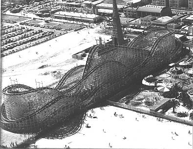
Photo source: Osterhoudt acquired collection (circa 1959)
The city management recommended, City Council-approved action
involving what was then the city's major tourist and downtown
draw (a 1968 city management letter said approximately 610,000
persons rode it in 1967) laid the groundwork for nearly all of
what followed in LB's downtown shoreline area.
Larry Osterhoudt, who has spent years documenting the ride's
design, size and precise location -- applied historical
materials with an engineer's precision and a detective's
persistence in examining the issue.
The Downey resident says GPS-technology reveals that while
then-city management claimed the southern (seaward) end of the
ride was in the way of a proposed new roadway [Shoreline Dr.],
the orientation of the roadway and one of its then-proposed
elements -- which was later removed showing it was never really
necessary -- effectively steered the road into a needless
collision course with what was then LB's biggest tourist
attraction.
As indicated in LBReport.com's report below,
Mr. Osterhoudt cites a swooping connector bridge -- built but
later demolished -- from Shoreline Drive to Magnolia Ave. that
helped push the northern lanes of Shoreline Drive into the
southern footprint of the Cyclone. The swooping connector bridge
was removed to make way for the Aquarium parking lot and a
simple ground level connector was used in its place.
As shown in GPS overlay photos below, Mr. Osterhoudt adds
that even with inclusion of the swooping connector, simply
moving Shoreline Drive about 100 feet south would have bypassed
the coaster and preserved it. He adds that if the roadway
weren't oriented at an angle, the distance might have been only
about 10 feet...and notes that there was plenty of then-vacant
area to the south.
He also notes that although Shoreline Drive weaves elsewhere
and doesn't adhere to a straight line, it didn't do so when it
could have avoided the southern tip of the coaster...which the
roadway sliced into on a diagonal.
Mr. Osterhoudt notes that City Hall's actions ended up
costing taxpayers money that included demolishing the swooping
connector to make way for the Aquarium parking lot.
That cost is in addition to the loss of LB tourism dollars in
giving up LB's then-biggest tourist draw. In contrast, two other
CA beachfront cities, San Diego and Santa Cruz, both preserved
their shoreline coasters, now historical landmarks (although
they're much smaller than LB's was) and created tidy tourist
revenue streams.
Mr. Osterhoudt says the record convinces him that in effect,
LB City Hall used a pretext for dooming the coaster to
demolition. (Stripped of its major attraction, the remainder of
the Pike died a decade-long death ending in 1979).
The actions begat a cleared area for City Hall and those it
chose to develop...and that process gave LB what it has now.
In 1968, then city management said in a letter to an L.A. TV
reporter that about 610,000 people rode the Cyclone Racer in
1967. That was at a time when the area's population, especially
OC, was a fraction of what it is today.
Like the Jergens tunnel -- entombed at roughly the same time
and unearthed to amazement decades later -- what LB City Hall
had and did with it are now visible.
"This was a little like CSI," Mr. Osterhoudt says. "The folks
who did this probably never thought we'd discover it, but we
did."
Mr. Osterhoudt has also re-engineered/re-created plans for
the Cyclone Racer that he says would enable rebuilding it to its
exact specifications...and has described this on his website
www.cycloneracer.com.
Archival Photos and Satellite Mapping
In 1967, newspaper accounts said the Cyclone Racer had to be
torn down to make way for a new planned roadway. Mr. Osterhoudt
decided to test this. After managing to find an Auto Club map
dating from that period (the roads have since been changed), he
plotted and overlaid the footprint of the Cyclone Racer.
His conclusion: the map overlay showed the planned roadway
would barely touch the southern end of the ride. In other words,
moving the roadway slightly south would have missed the ride and
preserved it.
Mr. Osterhoudt subsequently combined photos from that period
with Google's satellite mapping function and again plotted where
the Cyclone Racer was compared it to where the roadway was. This
shows the results in considerable detail...but to understand the
overlay requires a bit of orientation.
The Cyclone Racer stood on a pier that originally included an
observation deck or "patio" at its southern end.
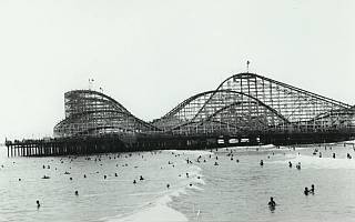
Photo source: Osterhoudt acquired collection
In 1968, the deck/patio was chopped off while construction
crews did roadwork...and a dirt berm was piled next to the
southern end of the ride.
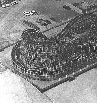
Photo source: Osterhoudt acquired collection
The coaster continued to operate during this period (its last
day was Sept. 15, 1968) and the dirt berm effectively marked the
ride's southern end.
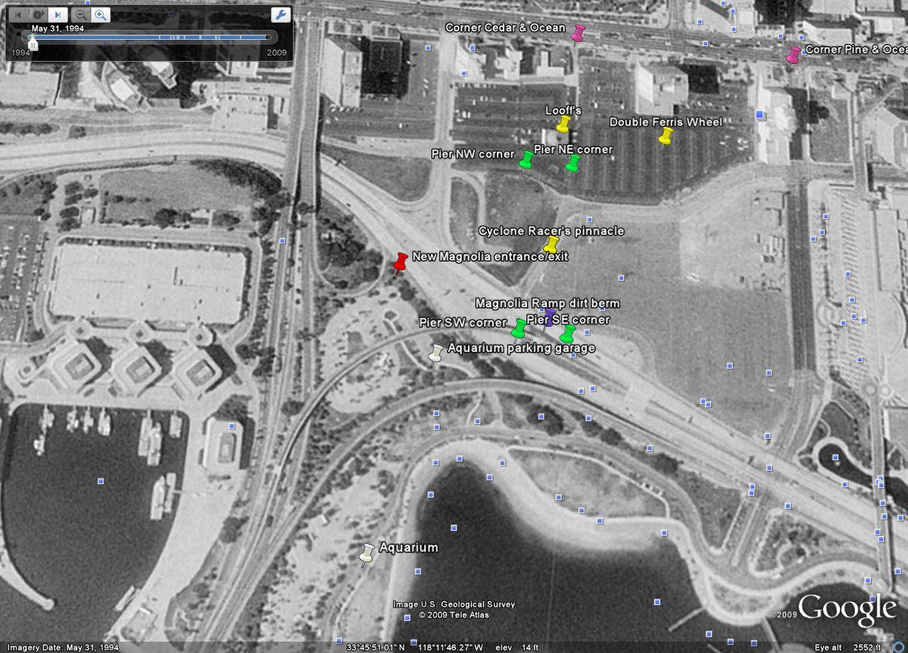
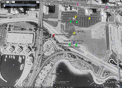
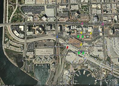
In the Google images below (which can be enlarged by clicking
on them), the four corners of the original Cyclone Racer pier
(with the original patio deck) are marked with green pins.
[Connect the green pins in your mind to envision the rectangular
outline of the original pier.]
The dirt berm (marking the southern end of the ride) is
marked with a purple pin.
The photo below is from May 31, 1994. Click the photo for a
detailed, high definition photo:
Due in part to accommodate a swooping Magnolia Ave. bridge
connector -- placed in the middle of Shoreline Drive but later
removed so it no longer exists today -- the northern lanes of
Shoreline Drive were shoved into the area occupied by the
southern tip of the Cyclone. Shifting Shoreline Dr. just
slightly southward would have preserved the Cyclone.
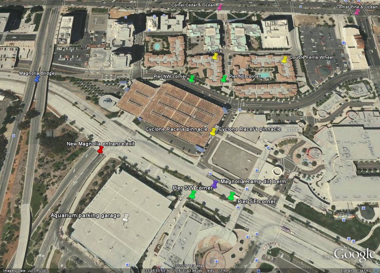
The photo below shows the curving Magnolia Ave. connector
alongside the bulldozed former Cyclone Racer site.
The curving Magnolia Ave. connector was eventually removed to
accommodate the Aquarium parking garage...meaning it didn't have
to be where it was in the first place. The Magnolia
entrance/exit was simply relocated 454 feet west of the Cyclone
Racer site to accommodate the Aquarium garage.
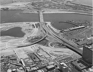
Photo source: Osterhoudt acquired collection
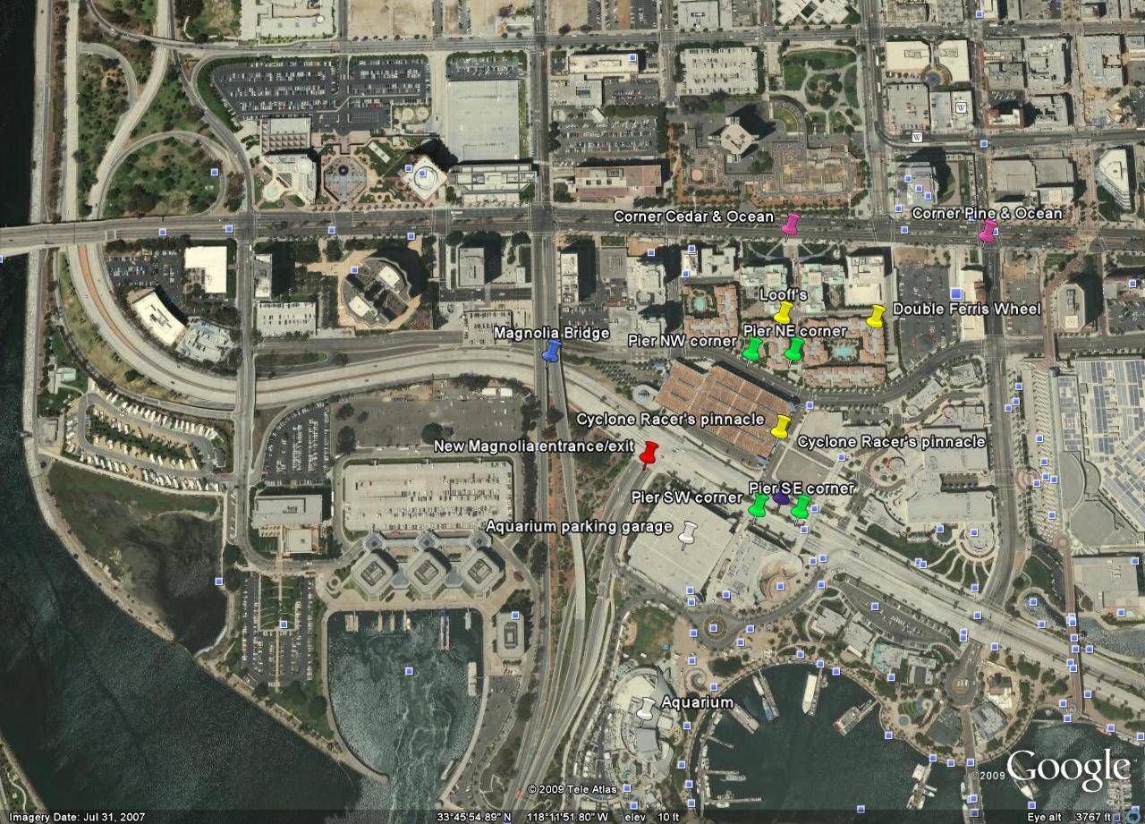
Below, a present day photo, showing Shoreline Drive without
the Magnolia Ave. swooping connector. Click image for detailed,
high definition photo.
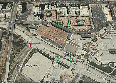
Below is a wider view, showing how Shoreline Drive weaves
elsewhere in its route.
Mr. Osterhoudt writes: "Take note to where the Aquarium
garage and the entrance/exit point to the Magnolia bridge are.
Notice how they routed it to accommodate for that Aquarium
parking lot? Compare this to the first image above, taken May
31, 1994. Look at how those ramps were routed to take out the
Racer. It is shocking, appalling, saddening and uncalled for!"
So...how was this done by LB City Hall at the time? Watch for
that part of this story coming separately...only on
LBReport.com. |